Walk into any big celebration after dark, and you will probably look up at one of two things. Either hundreds of tiny lights are lifting off the ground and arranging themselves into a logo, or a building you have walked past a thousand times is suddenly melting, growing, and telling a story.
Both are spectacular. Both get phones into the air. But they are very different tools, and event planners who treat them as interchangeable usually end up with the wrong one for their venue. This guide is for planners who have to choose. It covers how each works, what it needs from your site, and when to combine them, so the decision rests on your venue and your event.
A drone light show uses a fleet of small, lightweight drones, each carrying an LED that can change colour. Think of each drone as one pixel in a screen made of sky. Software plans a flight path for every drone in advance, and the fleet follows it together, with no one steering by hand. Satellite positioning, sharpened by a ground-based correction system called RTK, keeps each drone within a few centimetres of its mark, so the swarm moves as one picture.
The strength is freedom. The sky has no walls, so a show can draw a shape, dissolve it, and draw another, all in three dimensions. A countdown number can turn into a falcon, then into a skyline.
The limits show up in planning. Batteries cap flight time, so most shows run roughly ten to fifteen minutes, and your story has to fit that window. Wind and rain can delay or cancel a launch, so you need a backup date or a clear weather plan.
You also need airspace permission from the aviation authority. In the UAE, start that process well ahead of the date, because the show cannot be confirmed until it is cleared. You need a large, clear take-off zone too. And since each drone is a single point of light, there is no fine detail or photographic imagery. It is lines, shapes, and silhouettes.
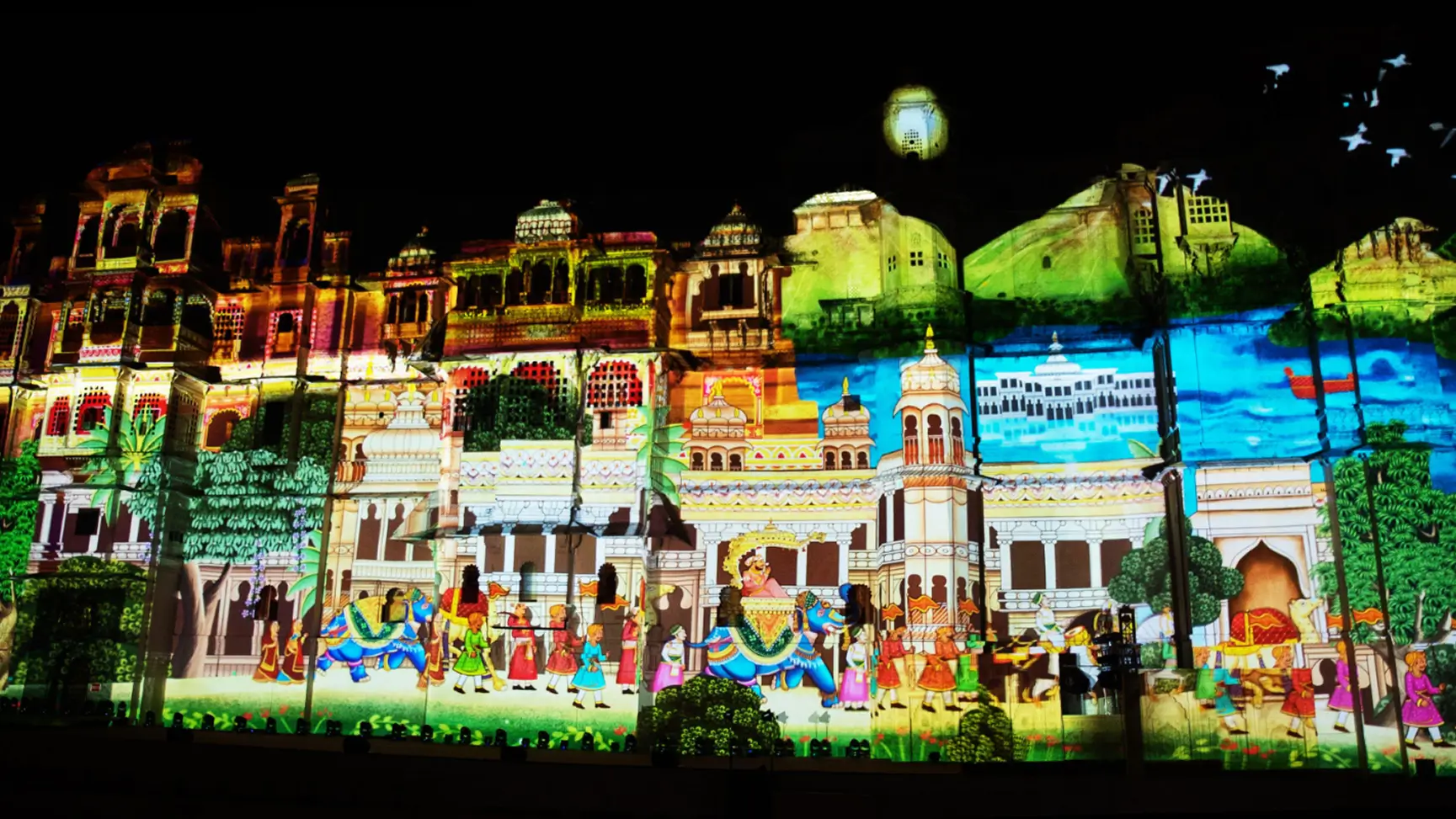
Projection mapping turns a physical surface, usually a building facade, into a screen. The team scans the building to record where every window, edge, column, and curve sits. Designers then build animation around those features, and high-powered projectors are aligned until the image locks onto the architecture.
That alignment is the whole trick. A window can glow like a lantern, a column can seem to crack open, a roofline can appear to grow. The building stops being a backdrop and becomes part of the story, which is why 3D projection mapping feels so different from video on a flat screen.
The limits are practical too. Ambient light is the big one: streetlights, signage, and a bright sky wash out the image, so the show works best in full darkness. Projectors need a clear throw distance, stable positioning, and power, and anything that blocks the beam, like trees, vehicles, or a crowd, shows up in the picture. The audience matters as well. The effect is designed for specific viewing angles, so people need to stand within a defined zone in front of the building. Watch from too far to the side and the illusion weakens.
| Drone light show | Architectural projection mapping | |
|---|---|---|
| Visual style | Glowing shapes and silhouettes in open sky | Detailed, full-color imagery on a building |
| Scale | Very large, seen from kilometers away | Tied to the size of the facade |
| Setup time | Mostly planning, permits, and site clearance, then a short on-site setup | Surface scanning and content design upfront, then one to several days of on-site installation |
| Cost drivers | Number of drones, permits, rehearsals | Surface size, projector count, content complexity, installation |
| Location needs | Large open launch area and safe airspace | A suitable surface and a clear viewing area |
| Weather sensitivity | High, especially wind and rain | Moderate rain and wind affect equipment more than visuals |
| Show length | Usually 10 to 15 minutes | Can loop for hours across an evening |
| Storytelling capability | Abstract and symbolic, told through shape and motion | Narrative, brand, and architecture-driven |
| Audience experience | Shared awe, watched from many positions and long distances | Close and immersive, best from the designed viewing zone |
Cost is deliberately described by driver rather than by number, because both vary widely with scale and location. A small facade can cost less than a mid-sized drone show, and a landmark-scale mapping can cost far more. The right question is not which is cheaper in general, but which one is cheaper for your specific venue and audience size.
When the goal is to say something about a place, projection mapping is hard to beat. A landmark already carries meaning. People know it, photograph it, and associate it with the city. Projecting onto it lets a brand or an occasion borrow that meaning instead of building it from scratch.
Picture a heritage building lit up for its anniversary. The facade opens as aged stone, the windows light up one by one, and the carved details trace themselves in gold as the history of the place unfolds. Nothing has been added to the site, yet people see it differently. That only works because the content was designed around that exact facade.
There are a few other reasons it keeps getting picked:
Detail. Projection can carry logos, typography, characters, product reveals, and full animated stories in colour. A drone formation can suggest a logo. A projection can show it in full resolution with the right fonts and shading.
Repeatability. A mapped show can run on a loop for an entire evening, so thousands of people who arrive at different times all see it. A drone show is a single moment that you have to be present for.
Permanence of content. The animation can be reused, adapted, or extended for later events on the same surface, which spreads the production cost over more than one night.
If you want to see what this looks like in practice, the team’s [Projection Mapping service page] shows how these builds are planned and delivered.
None of this makes drones the weaker option. They win wherever there is no building to work with, or where the crowd is too big for any single viewing zone.
Open venues. A waterfront, desert site, stadium, or park has no facade to map. There, the sky is the stage.
Large audiences. Because the show happens high above the ground, tens of thousands of people can watch from wherever they stand, without being funnelled into one viewing area.
Spectacle. Watching hundreds of lights move together overhead has an impact that is hard to describe until you have seen it. It feels like a moment, and moments are what festivals are built on.
Yes, and the combination is often stronger than either alone. A common structure is to open with a projection-mapped sequence on a landmark, with the building telling the story of the occasion, then move to a drone show in the sky above it as the finale. The audience gets the detail and narrative of the facade, followed by the sheer scale of the sky.
Here is a practical example. On a waterfront promenade with a landmark building facing the crowd, the night opens with a mapped sequence that tells the story of the occasion. As the final frame holds, drones lift from a launch area behind the audience and rise above the roofline, carrying the same colours and music into the sky.
For this to work, the two have to be designed together. Matching colour palettes, shared music, and a single timeline make the handover feel intentional. The last frame on the building and the first drone formation should land on the same beat, so the projection and drone teams work from one schedule and rehearse together on site. Produced separately and run back to back, the audience can tell.
Early site planning matters just as much. Launch zones, projector positions, crowd areas, and safety buffers compete for the same ground, and each decision affects the others. Moving the crowd changes the projection’s viewing angle and the drones’ sightline. Bring both teams into the site survey from the start.
National Day in the UAE, on 2 December, shows why the choice matters. These nights bring large crowds, tight schedules, and high expectations, and different sites in the same city can call for different answers. A heritage fort in the city centre has a facade worth mapping and a natural viewing area, so projection fits. A waterfront promenade has open sky and a crowd spread along the shore, so drones fit. A planner covering both might well use both.
For National Day projection mapping in the UAE, the strongest results usually come when the content is tied to a recognisable building or heritage site, because the story of the country and the place reinforce each other.
If you are weighing outdoor projection mapping in Dubai, start with three questions. What surface is available, and how good is the viewing area in front of it? How many people need to see the show, and from where? And how much of the evening do you want covered, a single moment or an extended experience? The answers usually point clearly to one technology or to a combination.
Whichever way you lean, lock in permits, site surveys, and rehearsal time early. Both formats look effortless on the night and are anything but in the weeks before.
Neither, and that is the honest answer. Drone lights show the open sky. Projection mapping owns the architecture. The best events start from the venue and the story, not from the technology, and then pick the tool that fits.
If you have a landmark, a facade, or a built backdrop, mapping gives you detail and control. If you have open space and a big crowd, drones give you scale and wonder. If you have both, use both.